


Stonex Cube-a GIS v7.x Software
Call For Pricing
Stonex Cube-a GIS v7.x Software Advanced Field GIS for Surveying Professionals The Stonex Cube-a GIS v7.x Software is a comprehensive field solution designed for professionals who require robust GIS capabilities integrated seamlessly into their surveying...
Click the button to call now
Stonex Cube-a GIS v7.x Software
Advanced Field GIS for Surveying Professionals
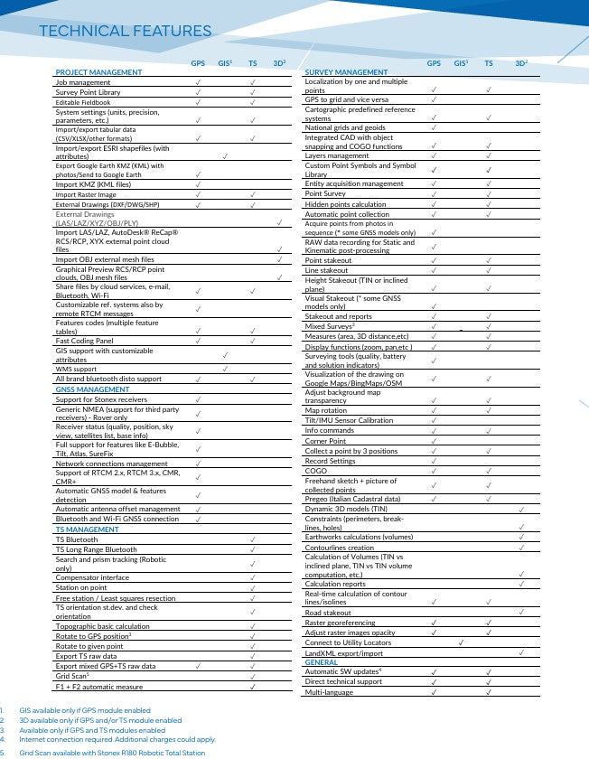
The Stonex Cube-a GIS v7.x Software is a comprehensive field solution designed for professionals who require robust GIS capabilities integrated seamlessly into their surveying workflows. Built on the Android platform, Cube-a GIS v7.x offers a user-friendly interface with powerful tools for data collection, analysis, and management, ensuring efficiency and accuracy in the field.
Key Features:
-
Integrated GIS Functionality: Capture, analyze, and manage spatial and geographic data within your surveying tasks. The software supports SHP format with all attributes, enabling database management created by third-party software, field editing of database fields, photo association, and creation of custom tabs.
-
Seamless GNSS and Total Station Integration: Cube-a GIS v7.x allows for seamless integration between GNSS receivers and total stations, enabling surveyors to switch between them effortlessly. This flexibility ensures the best measurement method for any scenario, streamlining data exchange and enhancing field data acquisition.
-
Advanced Data Collection Tools: The software enhances GPS workflows by automatically drawing vectors and allowing users to customize data forms through the Feature Set Designer. It supports shapefile, KML, and KMZ imports/exports, ensuring compatibility with a range of GIS software for easy data sharing.
-
Utility Mapping: Cube-a GIS v7.x features a Utility Locator for mapping underground utilities with customizable attributes, aiding in comprehensive infrastructure documentation.
-
Enhanced Visualization: The software offers WMS layer visualization to streamline field operations and improve workflow efficiency, providing surveyors with a clearer understanding of their working environment.
Why Choose Cube-a GIS v7.x Software?
Cube-a GIS v7.x stands out for its ability to integrate advanced GIS functionalities directly into the surveying process. Its compatibility with various data formats and seamless integration with GNSS and total station equipment make it an ideal choice for professionals in urban planning, environmental management, and transportation sectors. By providing tools that enhance data accuracy and workflow efficiency, Cube-a GIS v7.x empowers surveyors to deliver precise and comprehensive results.
Experience the power of integrated GIS and surveying with Stonex Cube-a GIS v7.x Software that's your solution for efficient and accurate field data management.