Stonex X120GO SLAM handheld 3D laser scanner for mobile mapping point cloud capture and as-built documentation
Stonex X120GO SLAM handheld 3D laser scanner for mobile mapping has a 360 degree point cloud coverage
Stonex X120GO SLAM handheld 3D laser scanner has multiple built-in cameras
Side profile for the Stonex X120GO SLAM handheld 3D laser scanner
3 side by side shots showing the full build of the Stonex X120GO SLAM handheld 3D laser scanner
Data specifications for the Stonex X120GO SLAM handheld 3D laser scanner for mobile mapping point cloud capture
An example of point cloud scanning done by the Stonex X120GO SLAM handheld 3D laser scanner
An example of the points made by the Stonex X120GO SLAM handheld 3D laser scanner

Stonex X120Go SLAM Handheld 3D Laser Scanner

Call For Pricing

The Stonex X120GO SLAM Handheld 3D Laser Scanner is a professional mobile mapping and 3D scanning solution designed for fast, high-precision point cloud data collection. Built for surveyors, engineers, construction teams, architects, facility managers, and...

Call For Pricing

Click the button to call now

Vendor: Stonex
Availability : In Stock Pre order Out of stock

visadiscoverpaypalamerican expressmasteramazon paymentsapple paygoogle payklarnashopify pay
Description

The Stonex X120GO SLAM Handheld 3D Laser Scanner is a professional mobile mapping and 3D scanning solution designed for fast, high-precision point cloud data collection. Built for surveyors, engineers, construction teams, architects, facility managers, and geospatial professionals, the X120GO makes it easier to capture indoor, outdoor, underground, and hard-to-access environments without the need for traditional static scanner setups.

The system features a 360° rotating head capable of generating 360° x 270° point cloud coverage. Combined with an industry-level SLAM algorithm, the X120GO can collect high-precision three-dimensional point cloud data of the surrounding environment even in areas without light or GPS. This makes it a powerful tool for building documentation, construction verification, tunnel mapping, infrastructure scanning, facility management, and as-built surveys.

The X120GO is equipped with three 5MP cameras that provide a 200° horizontal field of view and 100° vertical field of view. These cameras allow the scanner to synchronously capture texture information, generate colorized point clouds, and produce partial panoramic images for more complete visual documentation.

With the GOapp, users can check, manage, and preview projects in real time. Projects are updated and displayed synchronously, allowing crews to view SLAM mapping progress while collecting data in the field. This real-time workflow helps improve confidence during scanning and reduces the chances of missing important areas during data acquisition.

After field collection, GOpost can be used to process the collected data, generate high-precision and high-definition color point clouds, produce partial panoramic images, display point cloud data, and perform optimization processing. For office workflows, point clouds can also be managed with Cube-3D and Stonex Reconstructor Software. For users who need a different workflow, X120GO data can also be processed with PointCab, thanks to the collaboration between Stonex and PointCab.

The Stonex X120GO handheld SLAM scanner features an integrated structure with built-in control, built-in storage, and replaceable lithium batteries. Once the start button is pressed, the X120GO can begin operation immediately, helping make field data acquisition faster, more efficient, and more convenient.

  • Handheld SLAM 3D laser scanner for mobile mapping and point cloud capture
  • 360° rotating head with 360° x 270° point cloud coverage
  • Industry-level SLAM algorithm for scanning without GPS or light
  • Three 5MP cameras for texture capture and colorized point clouds
  • 200° horizontal FOV and 100° vertical FOV camera coverage
  • GOapp support for real-time SLAM mapping, preview, and project management
  • GOpost software for post-processing, point cloud optimization, and panoramic image generation
  • Compatible workflows with Cube-3D, Stonex Reconstructor Software, and PointCab
  • Built-in control system, storage system, and replaceable lithium batteries
  • Ideal for as-built documentation, construction verification, facility mapping, tunnel scanning, and geospatial data capture

Looking for more 3D scanning and surveying equipment? Browse our full selection of 3D laser scanners, GNSS/GPS systems, total stations, and survey field supplies.
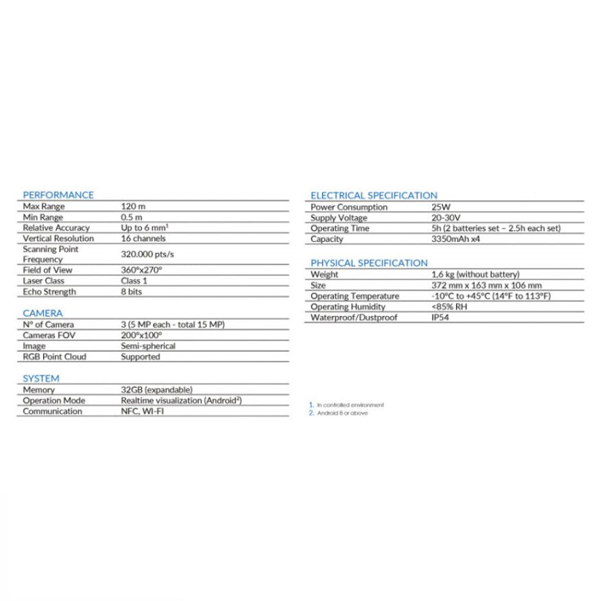
Specifications

Revolutionize 3D Point Cloud Capture with X120GO: Unmatched Speed, Precision, and Flexibility

Rapidity and Reduced Workload:
Experience a paradigm shift in 3D point cloud capture with X120GO. Bid farewell to multiple scan stations—simply navigate the scene to effortlessly collect the entire 3D point cloud. Say goodbye to time-consuming cloud-to-cloud alignment as you download the complete data immediately after capture, streamlining your workflow.

Flexibility:
X120GO redefines flexibility by seamlessly combining indoor and outdoor data in even the most challenging environments. Adapt to any scenario with ease, ensuring comprehensive data capture regardless of the complexities of your surroundings.

Real-Time Preview:
Immerse yourself in efficiency with a ± 5 degrees tilt supplement angle for precise leveling. A 360° one-stop scan takes just 45 seconds, providing a real-time preview of your captured data. Enjoy swift, accurate, and immersive scanning experiences like never before.

Automatic Control Point Measurement:
The X120GO goes beyond data capture by incorporating automatic control point measurement capabilities. While capturing data, the device effortlessly collects reference points. Match these points with known control points to georeference your scans, enhancing precision and reliability.

Integrated Cameras:
Elevate your point cloud experience with three integrated 5MP cameras covering a wide field of view. Capture colored point clouds and panoramic images simultaneously, adding a visual layer to your data that enhances analysis and interpretation.

Dedicated Accessories:
Unlock the full potential of X120GO with a suite of dedicated accessories tailored to complement and enhance your scanning experience. Maximize the capabilities of your device with purpose-built tools designed to meet the unique demands of your projects.

Unlocking Seamless Integration: Bundled Software for X120GO

GOapp: Mobile Empowerment
Immerse yourself in the power of mobility with GOapp, the dedicated mobile application for X120GO. Designed for the Android operating system, GOapp revolutionizes project management, offering real-time point cloud display, image preview, firmware upgrades, and other essential operations at your fingertips. Embrace a new level of efficiency and control while on the go.

GOpost: Windows Post-Processing Mastery
Take command of your data with GOpost, the Windows post-processing software accompanying X120GO. This robust toolset performs optimization processing, adds vibrant color to point clouds, and crafts breathtaking panoramic images. Elevate your scans by seamlessly importing control points for georeferencing, ensuring precision and accuracy in your final deliverables. Unleash the full potential of your data with GOpost.

Synergistic Power: Integration of GOapp and GOpost
Experience the seamless synergy between GOapp and GOpost, creating a powerful ecosystem that streamlines your workflow. Capture data with X120GO using GOapp on the field, and effortlessly transition to the optimization and enhancement phase with GOpost on Windows. Enjoy a comprehensive, end-to-end solution that ensures precision, efficiency, and flexibility throughout your entire scanning and processing journey.

Maximize Your X120GO Experience:
The bundled software suite goes beyond hardware capabilities, providing you with a complete solution for managing, enhancing, and presenting your 3D point cloud data. Embrace the future of 3D scanning technology with X120GO and its dedicated software, where seamless integration and powerful features redefine what's possible in the world of spatial data capture and processing.


Transform your 3D point cloud capture process with X120GO—where speed, precision, and adaptability converge to redefine the boundaries of what's possible in 3D scanning technology.

Reviews

Customer Reviews

Be the first to write a review
0%
(0)
0%
(0)
0%
(0)
0%
(0)
0%
(0)

Frequently Asked Questions

Can the Stonex X120GO Scan Without GPS or Light?

Yes. The Stonex X120GO uses SLAM technology to collect three-dimensional point cloud data in environments without GPS or light. This makes it useful for indoor mapping, underground spaces, tunnels, building interiors, and other areas where GNSS access is limited or unavailable.

What is SLAM technology, and how does the Stonex X120Go use it?

SLAM stands for Simultaneous Localization and Mapping. Unlike traditional terrestrial laser scanners that require static setups on a tripod, the Stonex X120Go utilizes a continuous 360° rotating LiDAR head and industry-grade SLAM algorithms. This allows you to simply walk through an environment while the scanner maps the 3D space and tracks its own position in real-time, eliminating the need for satellite GPS signals or targeted cloud-to-cloud alignment.

What file formats can I export from the Stonex X120Go workflow?

Through the Stonex processing ecosystem, you can export industry-standard formats compatible with top BIM, CAD, and GIS suites, including DXF, PLY, OBJ, LAS, and XYZ. You can always check the brochure linked here to get a bit more information on that.